
Arthur’s Pass Highway.
This can be a travel post of sorts. Well it’s not even of sorts; it’s a travel post. I went for a drive. I know I don’t write much anymore. Not sure why, it’s not like I’m short of things to say. I mostly spend my spare time taking photos these days. You’ll probably know that anyway. I’ll chuck a couple of photos in here to break up the words. (A couple of the photos aren’t from this actual trip, but the same trip recently. I’ve driven it a few times.)
Most of my readers aren’t from New Zealand so I’ll try to bear that in mind rather than assuming you know where the places are that I refer to. I’ll be more specific than I might if I was chatting to someone on the street.
Now I do love a road trip, short or long. My happy place is in the car and luckily for me as the case might be; I had to go to Christchurch for a meeting. Christchurch not quite half way down the East Coast of the South Island, probably about a third of the way down actually. But from my place on the lower West Coast of the North Island it’s about 562 Kilometres including a 3.5-hour ferry crossing from the North Island to the South Island.
The two islands actually aren’t all that far apart but there are only so many places you can park a ferry terminal so the crossing is longer than most might think.
So, I set off from my place in the dark to get to an early ferry in Wellington. Here’s my first tip. If you are taking a ferry, there are two companies operating. The Interislander and the Bluebridge. You choose which you prefer. If you choose the Interislander, sign up for their loyalty programme, ‘Nautical Miles’. It only costs $25 a year but you get a free premium lounge pass worth $40 for one crossing and you get priority boarding. So there’s free stuff right there. There are other benefits but priority boarding alone is worth it.
Hope for a smooth crossing, Cook Strait can cut up rough. I’ve crossed with waves crashing over the 8th deck. It’s a large ship.
I personally prefer to stand on the deck for the crossing rather than lounge about inside. There’s a lot to see out there. Albatross, dolphins, seals, even whales if you are lucky. Plus there are the amazing landscapes of the South Island looming in the distance as you sail. There are comfy seats inside if you just want to loaf about though of course.

The Kaikoura Ranges, from Wellington Harbour. Over 200 kilometres away. (Taken in October 2015)
Even if you do stay inside for the crossing. Go out to watch as you pass into the Marlborough Sounds through the Tory Channel. It’s a narrow channel where the churning ocean changes to become millpond calm as you enter the sounds. You’ll sail down Queen Charlotte Sound towards Picton for an hour or so. It’s unbelievably beautiful.

Crossing through the Tory Channel. (February 2016)
From Picton you have two or three choices which direction to head. This is about my road trip though, and I was heading for Christchurch.
You arrive in the Marlborough wine district sooner than you might think. If you are here for the wine, base yourself near Blenheim. This is where we grow most of our Sauvignon Blanc. For the record, I prefer the wines from Hawkes Bay.
It’s worth mentioning, if it’s your first trip to the South Island that you’ll encounter some shocking driving on the roads. It’s bad enough in the North Island, but the South Island takes it to a whole new level. To survive, assume everyone in any car you encounter is looking at the scenery rather than the road. Expect them to be on your side of the road around any corner. To be fair though, wait until you see the scenery. You haven’t got to the good stuff yet.
On State Highway One heading south, once you’ve left Marlborough and passed through Blenheim, you’re heading for the Kaikoura coast, which is one of the most beautiful places on earth. Bold statement, but it is, you’ll see.
No words do it justice so I’ll simply post a couple of photos.

State Highway One, north of Kaikoura, (taken in October 2015)

Stony beach near Kaikoura,(taken in October 2015)
You might like to stop at one of the many small shops to buy a small crayfish for an unfeasibly large price. Do it once and learn your lesson. Kiwis have learned that tourists will pay ridiculously large sums of money to consume things that should cost a lot less if it’s in a scenic location.
Beyond Kaikoura, is the Hurunui. The road winds through rough hills, forests and farmland until you arrive in the rolling country of North Canterbury. You’ll cross some huge braided rivers winding their way from the Mountains constantly visible to your right, to the sea. Once you are an hour north of Christchurch the road loses it’s appeal a bit for me. A series of small towns like Cheviot, Amberley, Kaiapoi. Little to recommend any of them, except you’re probably ready for a coffee, or a pie.
I’m not going to talk about Christchurch much. I was here for work. I would never come here for pleasure. It’s a sad, broken place. Wrecked by massive Earthquakes and fear of more. They should have bulldozed the entire city. A pall of anger, depression, anxiety and fear hangs over the city. I didn’t like Christchurch before the Earthquake and I like it even less now. I had my meeting and left as quickly as possible. My mood lightened noticeably.
Christchurch is on the coast, to the East of the Southern Alps that effectively run from one end of the South Island to the other. There are only 3 roads that cross the South Island. The Haast Pass to the South. Arthur’s Pass in the middle and the Lewis Pass to the North. They are each incredible drives. We were taking Arthur’s Pass. We being my partner and I.
To get to Arthur’s Pass, you drive across the Canterbury plains towards the Alps funnily enough. You can see them looming large in the distance, growing as you approach. The road suddenly starts to climb, and climb. There are surprisingly few people on the road really. We were there in February, still plenty of camper vans plying the roads like giant snails. Plus the ubiquitous rental cars, identified by the number plates or the writing in the rear window. Some simply by their driving habits.
They often travel 15-20 km/h below the speed limit, the worst We encountered was traveling at about 30 km/h (on a road with a 100 km/h limit) an hour while his passenger was videoing the mountains, completely oblivious to other road users. More dangerously, they are often on your side of the road. We drive on the left. Most tourists come from countries that drive on the right.

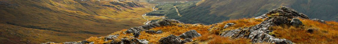
The Arthur’s Pass Highway, heading West
Arthur’s Pass though, in summer is a barren, alpine wilderness. Great rocky outcrops, scree covered mountainsides above the snow line. In the winter, much of the scenery is covered in snow. You drive through a parched landscape, in the rain shadow created by the mountains. Before long though, you are in temperate rainforest. It’s hard to credit the landscape could change so completely in such a short space of time.
So, you drive up the Alps, across the pass and down the other side. The most awesome vista here in my view is of the Waimakariri River. See?

The mighty Waimakariri River Valley at Arthurs Pass
Once you descend the Western slopes, you’re driving through rain forest until you emerge at the wonderfully named Kumara Junction. You can turn north and head for Westport and beyond, or the Lewis Pass. Or turn south, for Hokitika, Franz Josef, Fox Glacier and the Haast Pass back across to Otago. I turned south.
We were here to see the White Heron colony at Whataroa, and would be staying the night in Franz Josef. Franz Josef is a small town at the foot of the Southern Alps and the home to Franz Josef Glacier. Subsequently the place is heaving with camper vans and busloads of Asian tourists.
This is tourist mecca. The sky was full of helicopters ferrying the adventurous off the Glacier when we got there. They start early in the morning and retrieve the ice walkers at about 5pm. It’s like being at a busy helicopter base, which is what it is.
Expect to be over charged for everything at Franz Josef like any other major tourist site in New Zealand. It’s an undeniably beautiful location, full of people in bright coloured, expensive wet weather clothing and sturdy footwear.
We decided to get up at 5am to pop down to Lake Matheson near Fox Glacier, which is famous for it’s reflective qualities. I wanted to see the sun rise there. I hoped the clouds wouldn’t spoil the view. They did and they didn’t but being there at dawn was bucket list stuff ticked off. We could see the Mountains in the pre dawn light, the reflection was perfect but the clouds rolled in before dawn to obscure the peaks. We had a brisk one and a half hour walk all the way round the lake before the sun rose over the Alps. I’m not normally that energetic. Pretty awesome light in the mountains though.

Lake Matheson, pre dawn, about 6am

Awesome Sun rays at dawn. Near Fox Glacier
Back into Fox Glacier for an overpriced and underwhelming coffee before setting off for the point of this particular day which was the White Heron Sanctuary at Whataroa.
It was a birthday gift. I’m a keen photographer of native birds as well as our landscapes. What I know now is that it’s better to go to the White Heron Sanctuary at Whataroa a month before we did.
Still, we had a fantastic ride in a Jet boat into absolute remote wilderness. We got to see some White Herons. This is the only place in New Zealand that they breed. There are only about 30 breeding pairs. So unbelievably rare as well as incredibly beautiful.
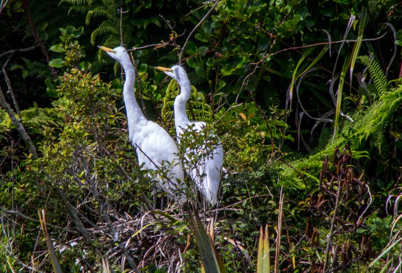
Two young White Herons.
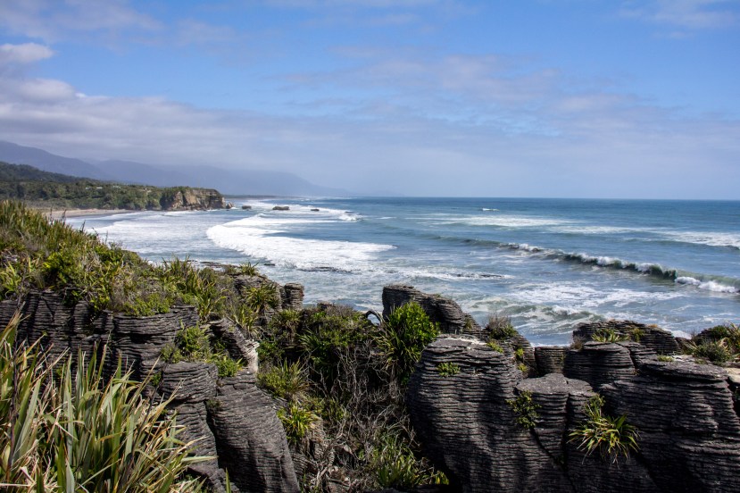
From here, to Punakaiki and on to Westport. The Punakaiki Rocks are another big draw for tourists on the West Coast. Stacks of rocks looking like piles of pancakes in a wild coastal setting with a rainforest backdrop. Definitely worth stopping for and the best bit is that it’s free. Actually the best bit is the scenery but I also like not paying to see it. They make up for the free scenery with the price of things in the adjacent shops.
You’ll notice I didn’t mention Greymouth, except you didn’t notice until now. I’d always found Greymouth to be a dreary name for a town and I’m sorry to say, it’s a bit aptly named. Maybe it was the overcast weather. As we pressed on north from Punakaiki though, the sun came out and the coast drive was simply incredible.

“The West Coast’ Looking North
Westport was next. Westport was the stop for the night at the excellent Westport Spa Motel. This is the place to stay if you are in this part of the world. We weren’t here for long and were getting a bit tired now. I can’t talk about Westport much as we slept and left.
To return to the ferry, one must navigate the Buller Gorge. My favourite gorge, which I believe is simply a name for a place where a river passes through a mountain range. The Buller Gorge is the best of our many gorges though. I know this now although I was unaware of it before.

Buller Gorge
We had one more night to spend in the South Island and I was returning to somewhere I had stayed before. It’s now the place I will always stay the night before my ferry north. Te Mahia Bay in the Marlborough Sounds, the Kenepuru Sound to be precise. The Marlborough Sounds are a collection of inlets with their own names, like Queen Charlotte, Pelorus, and Kenepuru. I’m not actually sure why a body of water is called a sound, or when a sound becomes a Fjord.
We needed supplies though so stopped at Nelson, which is the largest city at the top of the South Island. Nelson is very beautiful but apparently it’s where you go to retire if you have a lot of money. It seemed to be full of old people who were also quite rude.
We needed to get to my new special place now. Te Mahia Bay. To sit, watch, and listen the extraordinary calm and exquisite beauty. I don’t use exquisite much as a word. This place deserves it though. I mean just look at it. I’ll leave you with that. Our ferry home to the North Island was just an hour away in the morning. We want to stay here more and for longer.

Te Mahia Bay
New Zealand. Probably the best road trip in the world. This was just a little one. A few days and 2000 kilometres. It’s good to be home. New Zealand is home. I’m very lucky.
Categories: General views, Motoring, New Zealand, Travel

Nicely captured Sandy. We certainly live in the best little country in the world.
We really do
Beautiful photos Sandy. Thanks for taking us along on your road trip.
Road trips are best shared x
Couldn’t agree more.
Hey Sandy – how’s it going? Just realised it’s been an awfully long time since you posted and I miss your posts!
Cheers Gina, yes, the posts are few and far between
Take me with you on your road trip.. Those are great photos I would want to see in real 🙂
Cheers Happy Rabbit. Plenty of road for everyone. It’s just a short hop from the Phillipines
I know 🙂 visit Philippines soon
Hi Sandy
Re: The difference between a sound and a fiord. I am told that a sound as in the Marlborough sounds is a marine valley obviously filled with water, while a fiord is formed by past glacial action.
John McKenzie
Ta